Landmannalaugar · Southern Highlands
Laugahraun
4.8 km circuit1½–2 hours walking
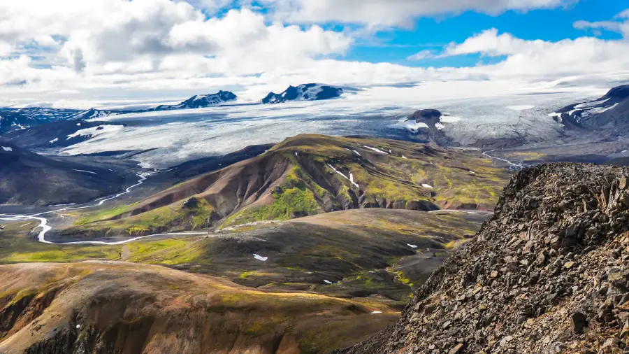
Gentler optionDark lava beneath colourful rhyolite slopes: a compact introduction to Landmannalaugar without committing to a summit.
A first Highland walk, photographers, or a shorter option when a mountain route is unsuitable. Allow extra time for stops.
- Terrain
- Uneven lava paths and modest climbing. Gentle here means relative effort; wind, wet rock and remaining snow still matter.
- Season
- Summer, once access and trail conditions allow
Access and return transport for Laugahraun
Reach Landmannalaugar by suitable Highland transport. Check road conditions, current parking rules and the return timetable before choosing your walk.
Skaftafell · Southeast Iceland
Svartifoss–Sjónarsker–Sel
5.8 km circuit · S2About 2 hours walking
ModerateBasalt columns, woodland and the turf buildings at Sel give this circuit more variety than a quick waterfall photograph.
Travellers staying along the southeast coast who want a substantial walk with a clear starting point and a return to the same base.
- Terrain
- Around 250 m of ascent, with steps and sections that become slippery. The park calls S2 easy; our category allows for the sustained climb.
- Season
- Choose suitable ground conditions; winter ice changes the walk
Access and return transport for Svartifoss–Sjónarsker–Sel
Start at Skaftafell Visitor Centre. Confirm current trail conditions there; these figures are for the complete S2 circuit, not the shorter waterfall return.
Þórsmörk · South Iceland
Valahnúkur
About 4 km1–2 hours walking
ModerateA relatively short climb above birch woodland opens onto Þórsmörk's broad valleys and surrounding mountain scenery.
A viewpoint day within a planned Þórsmörk visit. The trail's short walking time does not include the journey into the valley.
- Terrain
- A proper uphill walk, followed by a descent. The summit is exposed; visibility and wind determine how worthwhile the climb will be.
- Season
- When local trails and your transport are operating
Access and return transport for Valahnúkur
Confirm your arrival base with the transport provider. Langidalur, Húsadalur and Básar are different places; connecting walks can add time or involve river access issues.
Landmannalaugar · Southern Highlands
Bláhnúkur
4 km · FÍ summit routeAbout 3 hours walking
DemandingAn elevated view across Landmannalaugar's coloured ridges, lava and valleys, with the landscape opening as you climb.
Walkers comfortable with steep ascents and descents who have enough time before their return transport. Choose a lower walk when conditions do not suit.
- Terrain
- FÍ's dedicated route lists 330 m of ascent. Steep ground, loose footing and exposure make it a different undertaking from Laugahraun.
- Season
- Summer mountain conditions and suitable visibility
Access and return transport for Bláhnúkur
Start from Landmannalaugar and confirm the intended route with local staff. Longer circuits also carry the Bláhnúkur name; their distances are not interchangeable.
Jökulsárgljúfur · North Iceland
Hólmatungur circle
4.5 km circuit · H11½–2 hours walking
Gentler optionClear springs, green riverbanks and cascades meet the much larger glacial river: a different Iceland from the bare Highland plateaus.
A slower walking stop on a North Iceland itinerary, with time for the small streams and vegetation as well as the canyon scenery.
- Terrain
- The park grades the H1 circle easy. The separate Katlar extension has a harder grade; adding it changes the walk described here.
- Season
- Snow-free trails; confirm park and road access
Access and return transport for Hólmatungur circle
Start at the Hólmatungur parking area. Check local road information and park advice, especially outside the main summer visiting period.
Skógar to Þórsmörk · South Iceland
Fimmvörðuháls
About 25 km one way8–12 hours walking; allow a full mountain day
DemandingA long climb from waterfalls into volcanic mountain terrain, crossing between two glaciers before descending towards Þórsmörk.
Experienced, fit mountain walkers with an appropriate forecast and an achievable transport plan. A hut stop requires a separate confirmed reservation.
- Terrain
- Around 1,000 m of ascent, exposed high ground and possible snow. This is a committed crossing with limited easy exit options.
- Season
- Normally a summer crossing; verify current route advice
Route update · 2 September 2026: FÍ published a marked diversion around dangerous terrain near the pass. Check the latest route notice and local advice; older GPS tracks may follow the affected section.
Access and return transport for Fimmvörðuháls
Arrange the finish transport first. Confirm the collection point in Þórsmörk, departure time and sufficient margin for a slower crossing before setting out.
Landmannalaugar to Þórsmörk · Highlands
Laugavegur
Roughly 54 km one wayFÍ's standard itinerary: 4 walking days
DemandingA continuous journey from rhyolite and geothermal ground through lakes and black sands to Þórsmörk's birch woodland.
Hikers who want the classic changing-landscape crossing and are comfortable with consecutive days outside, shared facilities and weather-led decisions.
- Terrain
- Marked paths, meaningful climbs and descents, exposed stretches and unbridged river crossings. Daily effort rises with the weight of your pack.
- Season
- Summer trekking season, subject to snow and services
Access and return transport for Laugavegur
Book overnight stops and transport at both ends. Check that your dates work for the whole route; do not assume an available first hut guarantees the rest.
Kerlingarfjöll and Kjölur · Central Highlands
Ancient Trails
About 60 km of hiking across the trip6-day supported trip, including transfers
DemandingOpen central Highland country, old tracks, small huts and hot springs, with more space between the well-known visitor corridors.
Walkers who want local guiding and hut-to-hut continuity while carrying a daypack. Compare the daily walking demands, not just the total distance.
- Terrain
- Uneven horse tracks, lava and stretches without a clear path. There is a substantial climb and an optional summit; luggage support does not flatten the ground.
- Season
- Published summer departures
Access and return transport for Ancient Trails
Norse arranges the six-day journey, huts, meals, sleeping bags and main-bag transport. Confirm departure details and the equipment list before booking flights around it.